The United Nation’s satellite analysis programme, UNOSAT, uses geospatial information to develop informed, evidence-based solutions to issues of human security, peace and sustainable development.
Satellite imagery is proving to be a useful tool for innovation across many sectors, in particular when it comes to monitoring changes in the environment, such as environmental damage and climate change. Satellites are being used to track unsustainable land use and deforestation, monitor animal behaviour for conservation, enable precision farming and even to detect oil spills and reveal illegal fishing activities from outer space. But satellite data can also be used for humanitarian objectives too – in particular to ensure human safety and human rights in the face of natural disasters, violent conflict and the impacts of climate change.
The United Nations Operational Satellite Applications Programme, UNOSAT, is just one example. The organisation makes use of the 2,000+ satellites currently orbiting earth to provide satellite imagery analysis to UN bodies, UN member states and partners, and also offers training services to governments, regional and international organisations, teaching them how to apply geospatial technologies to help solve the challenges that they face.
One key aspect of UNOSAT’s work is its rapid mapping service. Here, UNOSAT translates satellite data into information-rich maps and reports and supplies them to humanitarian organisations providing relief on the ground in emergency situations, such as floods, earthquakes, storms, landslides, oil spills and violent conflicts. In moments of mass displacement like these, clear and trustworthy information is necessary to make sense of the chaos.
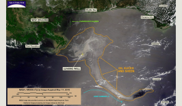
Most recently, UNOSAT has been providing critical information on the extent of floods and other damage across Nicaragua, Colombia and Guatemala as Hurricane Iota barrels across the Central American continent. UNOSAT’s maps can correlate population data with water surface area, for example, to figure out how many people are fleeing, and from where, to inform evacuation strategy. They can also compare recent photos with imagery captured before the disasters to reveal how badly infrastructure – such as roads and buildings – have been damaged.
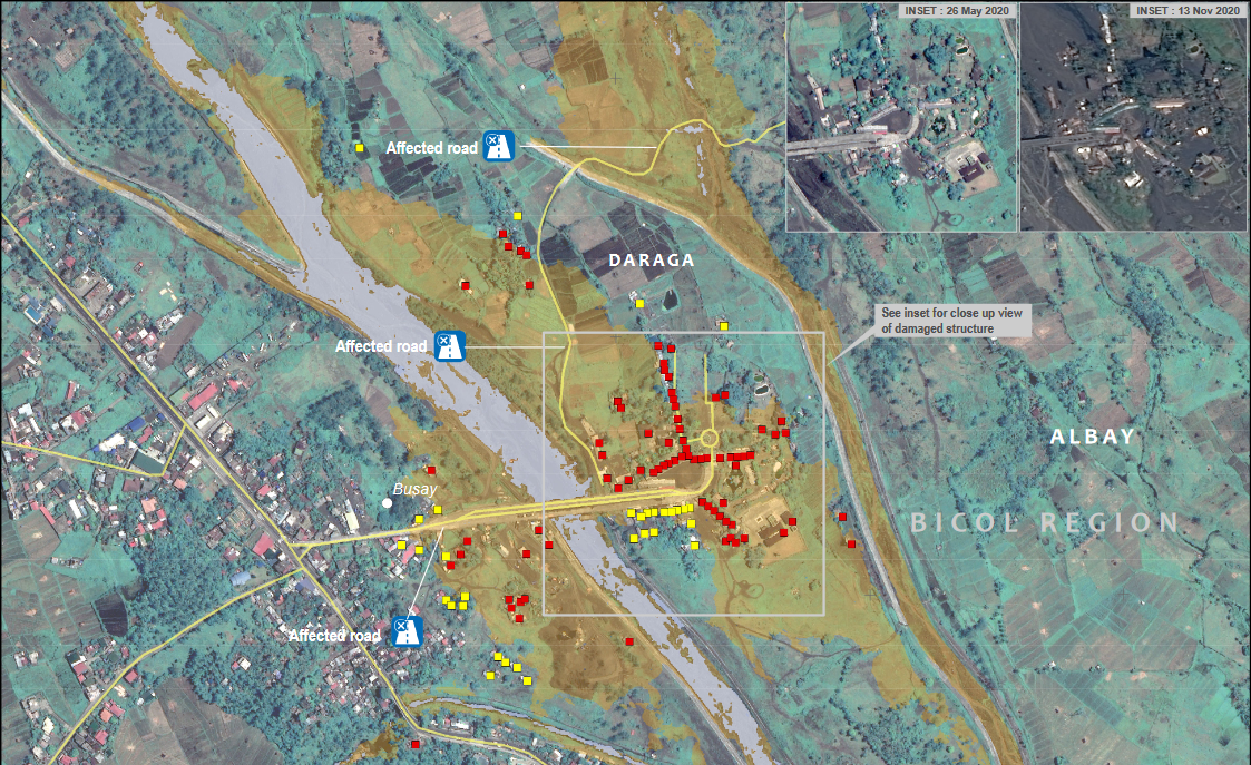
This video for example shows the damage assessment for a town in the Philippines in the wake of Tropical Cyclone Harold in April 2020. Carried out on the basis of satellite imagery, it demonstrates how it is possible to pinpoint which individual buildings appear to have been destroyed and which areas of the town are likely to require the most immediate assistance.
Satellite imagery analysis can also be used to help protect the human rights of vulnerable groups fleeing disaster. For example, during the conflict between the Philippines government and Moro separatists in 2013, satellite imagery showed aid organisations the extent of building damage to know which areas were safe and unsafe and set up housing strategies for the displaced groups.
UNOSAT provides maps, statistics and reports free of charge to any UN sister agency or humanitarian group. The geospatial information is helpful throughout four phases of a disaster scenario: 1. Contingency planning for disaster-preparedness; 2. Assessing the scope, scale, and severity of a crisis within the first 72 hours; 3. Assessing damage and planning a response within 2 weeks of the crisis; and 4. Monitoring reconstruction throughout recovery. “Having tools and analysis such as those provided by UNOSAT is not only extremely useful, it’s indispensable in the current world,” explained a United Nations High Commissioner for Refugees (UNHCR) stakeholder from Jordan.
Many of the maps created are available to access on the UNOSAT website, including in an interactive form that allows users to focus in on different areas and get an overview of a different situation – from flash flooding in Lao to the impacts of conflict in Iraq and South Sudan. You can even access the entire archive of all maps produced by UNOSAT in response to natural disasters and crises around the world since 2004.
The UNOSAT program is part of the UN Institute for Training and Research (UNITAR), so besides services in satellite imagery analysis, one of the main goals of the organisation is to build and develop capacities of member states in using earth observation (EO) and geospatial information technologies to help solve local challenges and work towards achieving the sustainable development goals. For ten years now they have hosted a 3-week masters level course in disaster management at the University of Copenhagen. In Chad, they recently collaborated on developing a water resources information system and strengthening local skills in hydrogeology in order to tackle the issue of water scarcity in the country. While in Guyana, they’re developing and implementing an early warning system to help forecast floods and help improve disaster preparedness and crisis response capabilities, with a particular focus on women and indigenous peoples who are vulnerable to natural disasters.
This article is part of the RESET Special Feature “Satellites for Sustainable Development”. Click here to explore all of the articles in the series.