Google has decided to abandon Project Loon - their ambitious plan to bring the internet to rural areas via giant floating balloons. But while this project shuts down, experiments with alternative solutions to the digital divide continue.
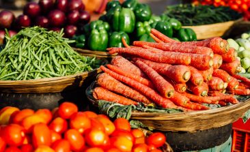
When most agriculture in the world is rural, getting crucial geoscience information to farmers is a technical challenge that a few organisations are just starting to figure out.
The EcoVision Lab at ETH Zurich is developing a tool that can accurately map biomass - all over the world - using remote sensing data. They hope it will make land-use planning more objective, transparent and environmentally-friendly, as well as protecting forests and biodiversity throughout the globe. We spoke to two of the brains behind the project.
Satellite data not only provides new insights, it can also be an important source of information for environmental and climate activists. But although the data from the missions of major space organisations are freely available, there are hurdles to accessing it. Both ESA and private projects are looking for solutions.
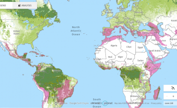
Global Forest Watch's satellite-based maps provide users with access to data on forests worldwide - and are an important tool in the fight against forest fires and deforestation.
Using satellite imagery and smart city technologies, researchers have discovered the real impact streetlights have on light pollution in our cities.
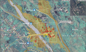
The United Nation’s satellite analysis programme, UNOSAT, uses geospatial information to develop informed, evidence-based solutions to issues of human security, peace and sustainable development.
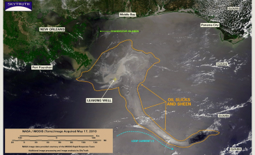
With a focus on oil spills, natural gas fracking and illegal fishing networks, SkyTruth’s work empowers NGOs and members of the public to become environmental watchdogs with a bird’s eye view.

A young company from Berlin wants to use 3D soil maps to make agriculture lower in emissions and more resource-efficient. Satellite and aerial photographs provide the data. Co-founder Suvrajit Saha explains to RESET in an interview how the soil maps are produced and who is benefitting from this new knowledge.