
Content to: drones
Digitalisation Can Advance Sustainable Agriculture – Under Certain Conditions
Digitalisation has long since arrived in agriculture. But how do these developments contribute to environmental and climate protection? We present solutions.
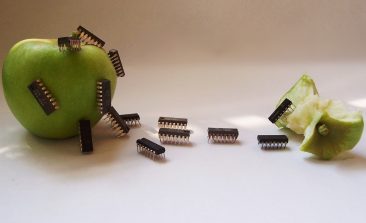
Edible Electronics: Reducing Electronic Waste With Digestible Robots and Nutritious Drones
Ever heard of edible electronics? Sounds like a contradiction in terms, but it could be a solution to reducing electronic waste, among other benefits.

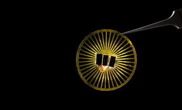
Cucumber-inspired Drones Collect Eco Data and Dissolve Into Nature
Researchers have developed a biodegradable drone with sensors designed to gather key environmental data in hard-to-reach locations.

Rainforest Protection With Digital Solutions: “Digitalisation Makes Developments Visible So That They Can No Longer Be Negated”
We spoke to Stephan Bohn from the Humboldt Institute for Internet and Society (HIIG) about the extent to which digital tools and platforms have an impact on rainforest protection in Indonesia.

Meet the Specialised Automated Drone That Can Swab for DNA in the Rainforest Canopies
Biodiversity field research is never straightforward — especially in the rainforest. However, a new automated drone is looking to make things a little easier.
Dandelion Seeds Inspire Lightweight Sensors for Mass Networks
Setting up sensor networks can be expensive and time consuming. A new project from the University of Washington has turned to nature for solutions.
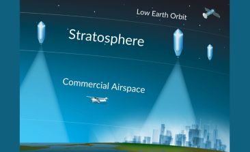
UrbanSky: Can Cheap Balloon-Based Images Help Disaster Relief and Civil Society?
A US startup hopes its 'mircoballoon' platform can provide aerial photography to a new host of users, including charities, farmers and rescuers.

Rainforest Alert: Combining Technology With Indigenous Rights to Help Protect the Amazon
Satellites have long been used to monitor deforestation, but how can that data be used to actively create results on the ground?

Donate to Worthy Causes this Holiday Season – 10 Project Recommendations for You
2021 was a difficult year for many, help make 2022 better with a charitable donation.