Star Spotting Technology Is Being Brought Back to Earth To Help Save Endangered Species

Infrared drones and machine learning software are helping track wildlife and stop poaching.

Technology that was originally developed for finding and identifying stars billions of miles away is now being put to use a little closer to home.

Autor*in Mark Newton, 04.11.18

Technology that was originally developed for finding and identifying stars billions of miles away is now being put to use a little closer to home.

When Serge Wich, a conservationist at Liverpool’s John Moores University, wanted to speed up the identification and cataloguing of wild animal populations, visiting the university’s astronomy department probably wasn’t high on his list of priorities.

However, as it turns out, a collaboration between the different scientific branches has resulted in an infrared drone system that allows researchers to quickly and easily locate, identify and log animals roaming in the wild – whether they’re obscured by vegetation or not.

The idea of combining infrared cameras with drones is not particularly new – they’ve previously been used in climate protection efforts and even to count migrating whales – and Wich himself had previously been working with such technologies in wildlife tracking trials in the UK. Although he was able to spot animals quickly, there was still the issue of how to identify the creature from great heights. Luckily, Wich did not need to look far to find an answer to his problem.

When lamenting this issue over the garden fence to his neighbour, and fellow John Moore’s University researcher, Dr. Steve Longmore, Wich was surprised to discover his astrophysicist friend had a potential solution in mind. Dr Longmore explained a colleague of his had been using similar infrared systems to find and identify stars in the solar systems, suggesting such a system could also be applied to terrestrial concerns.

Armed with this advice, Wich met another John Moore’s researcher, Dr Claire Burke, who had been working with software and technology used to identify distant stars via their unique infrared signature. Dr Burke was able to adjust the machine learning software to also identify animals via the same process, meaning the technology can rapidly idenfity and catalogue any wildlife spotted. After revealing the project at the annual European Astronomical Society, Dr Burke told the BBC:

“When we look at animals in the thermal infrared, we’re looking at their body heat and they glow in the footage. That glow is very similar to the way that stars and galaxies in space glow. So we can apply techniques and software used in astronomy for decades to automatically detect and measure this glow.”

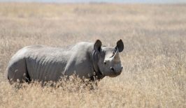
What’s more, the heat signature of an animal can also reveal hidden and useful information. For example, if an animal is wounded or injured, that area of its body will glow hotter, meanwhile an animal which is sick might also have a different heat profile to a healthy member of the same species. This method has huge advantages over the previous, more analogue, approaches which often relied on spending extended periods in the field or sifting through thousands of photos snapped by camera traps. Although AI learning machines are helping with the second method, Wich and Burke’s system can survey dozens of square kilometres in a single drone flight, saving huge amounts of time, labour and money in the process. This means the data can be put to more immediately and timely use in the fight against poaching and animal extinction.

So far, the field trials of the project has yielded promising results. In one search for the criticially endangered Riverine rabbit in South Africa, the team managed five sightings. An impressive haul when you consider there have been less than 1,000 recorded sightings of the rabbit in total, and there are possibly less than 500 adults currently alive in the wild.

Google’s Facial Recognition AI Helps Identify Endangered Species in the Wild – and Their Poachers

Facial recognition tech is the latest tool in the fight against poaching, with London Zoo embarking on a new trial which could drastically improve conservation efforts.A new project, developed in collaboration with Google, will use machine learning and image recognition software to identify and catalogue animals snapped by remote motion-sensitive camera traps.

This Mobile Game Uses AR so You Can Track Endangered Species Using Real Wildlife Data

A US and Kenyan start-up is using real-world data from endangered wildlife to create an augmented reality game to track animal movements.The Safari Central app, available on iOS and Android right now as a preview version of the final game, lets players follow real animals based on GPS data logged by National Parks and conservationists.

The Drones Soon to be Planting 100,000 Mangroves Each Day in Myanmar

Hovering low over the ground and shooting mangrove seeds into the water, drones may become a common sight in Myanmar by the end of the year. It's part of a reforestation project that aims to restore a natural ecosystem that is beneficial to wildlife, the environment and the local population.

How Satellites Can Monitor the Migration of Small Animals

ICARUS tracks the movements and migration patterns of small animals with the help of data chips and satellites. If you’ve ever seen any animals documentaries filmed over the Serengeti, you already know that herds live and roam around the Savannah, particularly gnus, zebras and antelopes.

PAWS: Artificial Intelligence Helps Patrollers Hunt for Poachers

Computer scientists from the University of Southern California (USC) developed an artificial intelligence tool that helps prevent poaching by predicting where it is likely to happen and suggesting patrolling routes.

Star Gazing in Ethiopia: Could Space Science Propel Development?

The first space observatory in East Africa opened last year in Ethiopia, launching new educational opportunities for local students and scientists. But could a space programme benefit a country grappling with issues such as food security and drought?

Drones and Satellites for Good – Satellites Detect Illegal Logging in Myanmar

More than half of the contiguous remaining forests on the mainland in Southeast Asia are found in Myanmar. These forests are home to many species of animals and plants and are a source of food and protection from flooding (among other things) for the local population. Unfortunately, the rate at which these forests are being illegally cleared is increasing.

Drones and Satellites for Good – Wildlife Watching from Above

Wildlife conservationists are constantly having to up their game to stay two steps ahead of criminal poachers. For a proper bird's eye view, a handful of organisations are looking towards the sky, using satellite technology to help protect species on the ground.

Unmanned Drones Used to Protect Endangered Vaquita

The Vaquita is the smallest of all cetaceans, and is one of the most endangered marine mammals in the world - along with whales, dolphins, seals, manatees, sea otters - with less than 100 of them on the planet. Mexico is testing the use of unmanned drones to help protect the critically-endangered Vaquita from being killed by illegal fishing activities in the Gulf of California.