The world is fragile. Everything is interconnected. To really truly comprehend this fact though, it might to be astronaut and look down on the Earth from the International Space Station (ISS). But unfortunately this awe-inspiring view is one that most of us will probably never get to experience. Satellite data can offer an alternative. They give us a view of Earth from above, just like what an astronaut can see. And that’s not all: satellite data contains crucial information about life on our planet. While access to this data, which at first glance might not look very impressive, is usually reserved for experts and scientists, it’s actually open for everyone to see – at least in theory.
Earth observation data: “One of the most important tools we have for making people realise that we need to protect our planet.”
NASA’s Landsat program was the first freely available satellite program – a significant step toward making data public. That was more than 12 years ago. Many other public space agencies have since followed suit. “Open earth observation data is one of the most important tools we have for making people realise that we need to protect our planet,” says Sabina Dolenc of Sentinel Hub. The company works closely with the ESA.
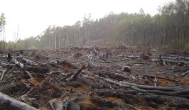
Whereas years ago you needed a folding rule, writing pad and pen to collect the data by hand, today it can be retrieved in a short time. The satellite images show whether forested areas have shrunk due to deforestation or due to the construction of industrial sites. It’s just as easy to see whether reforestation projects are developing as planned. It’s no longer necessary simply to rely on information provided by a company or the administration. Thanks to modern Earth observation systems, everything can be verified. This can be of huge help to, among others, civil service initiatives and environmental organisations.
But the possibilities go beyond simply viewing and comparing satellite images. Combining different images can provide information on the health of vegetation or soil hydration levels. It’s even possible to identify the chlorophyll content of vegetation. Some of these possibilities are already being applied. For example, researchers were able to prove that forest fires in the Arctic increased last summer, and Twitter users found out that a Siberian river was polluted after an oil spill. It was only thanks to the tweets that the Russian government learned about the environmental disaster and reacted. So the potential of the data is huge. Every change on our planet is traceable, documented and freely accessible. However, users still have to meet a number of requirements in order to access the data.
How accessible is the open data really?
ESA provides several ways to retrieve data. In the so-called SciHub, you can get all the information you need. One way is to navigate through the data using a search and a graphical user interface. The problem is that users need to know exactly what they are looking for: Which satellite mission is collecting the data? Which satellite was over the location from which data is needed at the time? Which sensor on the satellite measured the appropriate data? You need basic professional and technical knowledge of the satellite services on offer in order to be able to use it.
An alternative, which is no less complex, is the ESA API. If users want to retrieve data from this programmatic interface, you also need specialist knowledge and an understanding of programming language Python.
The ESA does not currently offer a simple alternative to these two options – a major hurdle for people who are approaching the topic for the first time. Developer Jérôme Gasperi confirms this: “Even if you know exactly what you’re looking for, you need a technical background or a minimum of computer science knowledge to get the information you need.” With his app SnapPlanet, he therefore wants to give everyone access to satellite data.
ESA accepts the challenge – but recognises dangers too
ESA is facing a dilemma: On the one hand, they want to make the data as accessible as possible to everyone and, above all, easily accessible. On the other hand, satellite products are complex technological and functional data structures. So ESA has to serve two different audiences. Scientists, industry employees and other professional users need the complexity of the data to develop forecast models or detailed analyses. Journalists, citizens’ groups and activists just need straight-forward access to the data. “We always have to make a trade-off between the meaningfulness of the answer and the simplicity of the interface,” says Dr. Nicolaus Hanowski, Head of the Ground Segments & Mission Operations Department.
It’s the key challenge. As evidenced by Dr. Hanowski’s statement, “If you are interested in vegetation health, data on soil moisture could be as relevant to you as chlorophyll content in leaves or even the area covered by leaves in a given area. Are you looking for data with global coverage, or are you just examining a small area but need higher resolution? This shows the complexity of such data queries.”
ESA is trying to solve the challenge in two ways: By providing assistance and by partnering with different companies. “With portals like the Sentinel Data Hub, EO Browser or ESA Earth Online, we want to offer interested individuals from civil society access to Earth observation data” says Dr. Hanowski and explains further: “Not only can you download data collected by our satellites, but you can also learn how to use the data. For this, we provide a variety of resources with background knowledge and tutorials on practical application.”
In fact, ESA offers a wide range of explanations online at ESA Earth, presented in multimedia form. Users can learn more about individual satellite missions and which sensors detect which problems. They can also learn how to process the downloaded data using ESA’s own free SNAP software. In addition, there are regular training courses, webinars and online workshops, which are often attended by several thousand people from all over the world.
If you have a specific request, for example a research project, and you need help selecting the right data, you can also contact ESA directly. The mission managers can then help you with the selection of the right data and with the processing of the satellite images. They also provide support with the analysis. “ESA responds to dozens of requests every day,” says Hanowski.
ESA collaborates with startups to improve accessibility
Another solution is Sentinel Hub, a cloud software. It was developed by the European Space Agency and the Slovenian startup Sinergise. With the help of the software, users can search data from ESA and other national space agencies, view it and analyse it. “There is no need to download imagery from ESA’s SciHub,” says Sabina Dolenc of Sentinel Hub, adding, “There is also no need for large storage volume on your own PC or much computing power.” One can simply use the resources from Sentinel Hub.
The advantages are clear:
- Thanks to the cloud, users do not have to install anything on their own PC. There is no need to learn how complex software works.
- The data does not have to be downloaded. This is helpful because the data can be several gigabytes. Depending on the size of the area to be examined and the quality of the Internet connection, this can take some time to download.
- The processing, i.e. the combination of different data to obtain a certain result, is done by the user in the browser.
Ultimately, however, the tool is also aimed at a specialist audience. This is because so-called custom scripts, i.e. small programming scripts, are required in order to be able to link the data together. There are prefabricated scripts that can be inserted into a corresponding field by copy-pasting them. While technical knowledge is required to be able to use them, this software does makes it much easier to take your first step into the world of earth observation. The tool also offers many ready-made functions for simple time-lapse recordings or comparing images. So, if you have an hour or two, it is technically possible to explore many worlds via Sentinel Hub.
Due to the close cooperation with ESA, the use of this cloud software and the data is free of charge for non-commercial purposes – which should be a great advantage for many, especially beginners.
Instagram for satellite imagery
SnapPlanet takes a completely different approach: The app, which originated as a private project by Frenchman Jérôme Gasperi, is a sort of Instagram for satellite images. And Gasperi has a clear mission: “The vast majority of satellite data is paid for by citizens. Landsat data, for example, is paid for by US citizens, and Sentinel data is paid for by EU citizens. So in a way, it should be normal for all citizens to have free access to this data.” Open satellite data, that’s his goal, and he adds, “Also, I think it will help citizens, journalists and scientists tell stories that can have a positive impact on society and our environment.”
Accordingly, the app’s interface is easy to use: Users select the location on the world map from which they want to “snap” an image or animation. The application then provides all available images from the Sentinel-2 satellites and suggests the best image. Alternatively, users can search the image archive themselves. Once the right image has been found, various filters can be applied to it. This allows water, for example, to be placed in the foreground. Or different types of soil or rocks can be highlighted in the image. The image can then be saved. Time-lapse animations can also be created from several images of the location. More satellites are set to be added in the future.
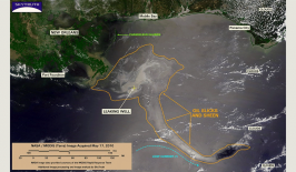
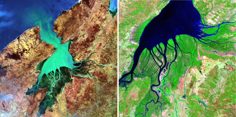 © View of the Betsiboka River Delta, Madagascar, with different soils (left) and vegetation (right) made visible.
So far, a small but active community has formed on the app. “There are two types of users – artists and scientists,” Gasperi explains. “Artists are more interested in colours and shapes to take beautiful snapshots of places on Earth. Whereas scientists are more likely to use SnapPlanet to check the availability of data about a particular place or to report on their work. For example, glacier researchers use animated snaps to show the shifting of glaciers that are very visible from space.”
A digital twin inspired by the gaming industry
With a new project, ESA wants to make satellite images accessible to citizens in a completely new way: Digital Twins Earth. The project was decided on in the European Commission’s Green Deal. The goal is to create a digital copy of the Earth. Various models and simulations are to run on the copy. For example, natural and human activities could be virtually simulated on it. “This will help us test and evaluate European measures for sustainable development,” explains Dr. Nicolaus Hanowski with conviction.
In the pioneering project, data from Earth observation will be merged with various other data – social data, measurements from agriculture and physical movement data. For example, predictions could be made about crop yields or even physical changes on Earth. Similar to the models used in climate science or meteorology, it should be possible to make predictions about movements on the Earth’s surface, such as landslides.
What sounds like a very complex application in theory should be available in as little as two to three years. “What is fundamentally new about it is that we have also taken inspiration from the gaming industry in developing the user interface,” says Hanowski. “This means that we should be able to influence the parameters in a playful way in the simulations. IT knowledge is no longer necessary. This way, this data and information will become accessible to an even wider audience and we’ll create new prediction possibilities.”
It remains to be seen what innovations there will be in this area in the future. The fact is that new tools, startups and opportunities for Earth observation are always being developed. And while the vast majority are geared more toward professional users: ESA and other national space agencies have recognised the opportunity of freely accessible data. They are working on new ways to make the data available – simply and easily accesible for everyone. Because ESA is also aware that the data holds tremendous potential for the global challenges of our time, as Nicolaus Hanowski confirms: “For ESA, making our data available to the largest possible group of people is one of the central challenges of the next few years.”
This article is part of the RESET Special Feature “Satellites for Sustainable Development”. Click here to explore all of the articles in the series.
This is a translation of an original article that first appeared on RESET’s German-language site.