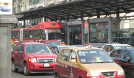
In cities around the world, public space is hot property. Nowhere is this more prominent than at the side of the road – where shared scooters and bikes, delivery vans, buses, ride-hailing vehicles, parked cars, cyclists and pedestrians compete for the limited space available. The battle is getting tougher and more dangerous too, with taxis and delivery services quick to switch to footpaths and cycle paths, putting the most vulnerable road users at risk. We need to manage our curbs better – to build, regulate and manage transportation infrastructure in a way that works best for everyone.
The US startup Coord wants to help. In April 2019 they launched “Open Curbs“, an open data platform that provides digital maps showing the exact location of fire hydrants, parking zones, wheelchair cuts, driveways, bus stops and more. Until now, city planners, mobility companies and everyone else who required this kind of information had to carry out their own time-consuming and resource-intensive investigations to find out it out for themselves. With Open Curbs, this data is now available in a digital form and freely accessible as an open API.
The platform wants to put an end to the current information silos that exist on curb use – bridging the information barrier between the public and private sectors for the benefit of both. City planners and public authorities can use it to improve public transport, for example, but tailoring it more effectively to better suit specific sites. Bike and car sharing companies can also use it to adapt their services to the existing infrastructure and therefore operate more effectively. And research projects looking at the routing efficiency of traffic jams, delivery companies and parking apps are also using the data. In a press release, Coord writes that its platform has created a “shared language for the curb”, enabling all users to work together. “We are raising the water level so that all boats can float,” explains Coord CEO Stephen Smyth.
Coord is a spin-off of Alphabet (Google’s parent company) and collects the data for Open Curbs mainly through its own augmented reality app Coord Collector, which uses AR to This information is then combined with data from existing platforms like Google Street View. Using machine learning, the app is able to digitally visualize one whole city block within an average of three minutes.
Free of charge, easy to use and accessible to all
Collecting and keeping data like this up to date has been an expensive and laborious task for individual cities. “Originally, we were inspired by the efforts of many cities to create open data portals,” Sara Wiedenhaefer, Marketing Manager of Coord, told RESET. The cities of New York and Seattle provided Coord with data on roadside usage early on in the process. “We wanted to create a way to forward this data to other cities.” Because each city saved its data in different format, they created a common standardised method for saving the information on their open platform. Via Open Curbs, the information can now be shared between cities, freely and openly and in a standardised way that all of them are able to work with.
Coord has already set about mapping the curbs in several different countries – not just collecting accurate curb data in large US cities (Santa Monica, Denver, Los Angeles, San Francisco, San Diego, Miami, Washington D.C., Austin and Philadelphia), but also in Paris and Milan, all of which is now accessible via Open Curbs.
Open Curbs could also help counteract the traffic chaos that’s endemic to so many city centres. The nterdisciplinary approach and the focus on connecting and networking different actors has huge potential. For the data to truly have a sustainable and lasting impact, both the public and private sector will need to work together. Only with compromise and joint planning can the pressure on our city’s curbsides be reduced and the space used more effectively. And the Open Curbs platform could certainly help deliver key data to allow for that kind of meaningful exchange.
Even with the best networking in the world, however, roadside space is and always will be limited, and increasing numbers of different types of road users will always put pressure on the space available. That’s why it’s important to continue working on solutions and strategies that reduce the numbers of vehicles clogging up our city centres – helping reduce urban CO2 emissions for the good of the planet and human health in the process. Cover the so-called “last mile” using e-bike couriers and cargo bikes rather than conventional vehicles, is just one example of a small step in the right direction
This is a translation by Marisa Pettit of an original article that first appeared on RESET’s German-language site.

This article is part of the RESET Special Feature “Artificial Intelligence – Can Computing Power Save Our Planet?”
The RESET Special Feature on AI is part of a project funded by the Deutschen Bundesstiftung Umwelt (German Federal Environmental Foundation DBU). As part of this project, over a period of two years we will be developing four RESET Special Features on the topic of “Opportunities and Potentials of Digitalisation for Sustainable Development”.
You can find more information here.