As human populations expand and encroach on natural habitats, conflicts between humans and wildlife become increasingly common. A recent bear encounter in Italy highlights the challenges and complexities of managing such conflicts. Luckily, researchers are exploring innovative ways to promote coexistence between humans and these majestic — if potentially life-threatening — animals.
Italy’s bear encounter shakes trust in existing structures
In Italy, a 17-year-old female bear known as JJ4 was captured after she killed a jogger named Andrea Papi in the Alps. Another bear, MJ5, had attacked a hiker in the same area just weeks earlier. According to Nature, there is a worldwide bear attack rate of approximately 40 attacks per year. North America and Europe face 11.4 and 18.2 bear attacks per year, respectively. However, it’s not just the bears and wolves that suffer; humans are responsible for 71 percent of grizzly bear deaths worldwide.
Despite a successful appeal from environmentalists to save the Italian bear, the culling of large numbers of bears, and other potentially dangerous wildlife such as wolves, occurs in many parts of the world. For example, in 2023, Slovenia’s Minister of Natural Resources and Territorial Affairs called for the culling of 230 brown bears, citing concerns about population size and safety.
Modern solutions to an ancient problem
Despite humans and bears having coexisted for centuries, these recent events have highlighted the need for greater protection for both parties. To address these complex challenges, innovative solutions are emerging. One such solution is being suggested by Paula Mayer, a researcher at ETH Zurich, who has developed a participatory model of digital mapping for human-bear coexistence using the Apennine brown bear as a case study.
The Apennine brown bear, a subspecies of the European brown bear, is endangered, with a population of around 70 in the Abruzzo, Lazio, and Molise National Park region in Italy. Aside from human encroachment on habitat and the ever-present threat of culling, these bears also face human-made threats such as highway accidents and poison baits laid out by truffle hunters.
To mitigate this, two local non-governmental organizations (NGOs), Rewilding Apennines and Salviamo l’Orso, supported by the European organization Rewilding Europe, are developing so-called ”coexistence corridors”. In these zones, which include and connect suitable bear habitats, human-bear conflict is prospectively minimised, and economic opportunities such as wildlife tourism are made possible for the local community.
Paula Mayer’s ‘Bayesian network model’ integrates local and expert knowledge with spatial data, and aims to support local authorities, conservationists, farmers and tourism specialists in identifying areas and measures that should be prioritised to promote human-bear coexistence. This practical tool generates coexistence maps that help track changes in bear-human interactions over time and assess the effectiveness of mitigation measures.
“This project is an attempt to take a rational look at the landscape and figure out where and under what circumstances humans and large carnivores successfully coexist and where they don’t,” Mayer explains.
Balancing the needs of humans with those of native wildlife with digital mapping
Mayer’s model takes into account factors that represent both human and bear perspectives. Human factors include community tolerance levels, the presence of protective measures like fences and the availability of bear-proof waste disposal facilities, orchards and livestock. On the other hand, bear factors encompass suitable habitats, migration corridors and access to human-made food resources.
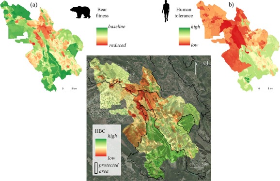
By linking these factors, Mayer’s model creates maps that illustrate areas where human-bear coexistence works well and areas where conditions are less favourable. The flexibility of the model allows for adaptation to other regions or species, such as wolves, making it a versatile tool for addressing wildlife-human conflicts worldwide.
“If the model produces a map that shows areas of low coexistence despite measures like fences to protect beehives from bears, you can infer how effective a measure is – and whether other measures might be better for promoting coexistence in that location,” Mayer says. “That’s something we can assess very well – or even predict – with the model.”
While the model created in this study is tailored to the Central Apennines, its approach, which integrates various perspectives, holds broader applicability in the field of conservation. With the resurgence of large carnivores in European habitats, the utilisation of expert knowledge and publicly available spatial data to map the likelihood of human-large carnivore coexistence has the potential to pinpoint priority areas for enhancing coexistence conditions. This proactive approach can preempt conflicts, safeguarding both human and wildlife well-being. The model itself can and should be customised to the specific local context, to ensure the model’s effectiveness in supporting local conservation decisions, and the emphasis on each perspective should align with local priorities. This is possible given the model’s modularity.
Innovative approaches like Mayer’s participatory model offer hope for peaceful coexistence between “man and beast”. As humankind continues to navigate the ever-pressing challenges of human population growth, it’s imperative that we continue to develop and embrace forward-thinking solutions to protect our planet’s delicate ecosystems and the magnificent creatures that inhabit them.