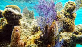
According to the World Resources Institute, around 60 percent of the world’s coral reefs are endangered. Unfortunately, that figure is rising and by 2030 it is expected that around 90 percent of all coral reefs will have been threatened by the ocean warming and acidification that results from rising CO2 emissions.
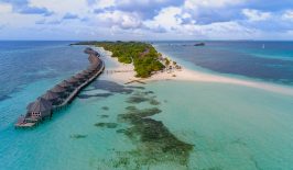
In a fight to protect what is left from future threats, NGOs in the Dominican Republic are working to ensure they have the information they needed to better monitor and protect local coral reefs. The Nature Conservancy (TNC) and Global Airborne Observatory (GAO), in collaboration with a range of Dominican environmental agencies, have developed an advanced method to better understand what is going on beneath the waves – drawing up a new range of highly detailed maps which provide an unprecedented overview of the health and makeup of its coastal waters, 11 percent of which feature coral reefs.
In order to create these new maps, a plane was fitted with a range of advanced sensors and camera equipment which could capture images with a much broader hyperspectral profile than normal. Essentially, this means the camera is able to capture hundreds of bands of light, which usually go undetected by a traditional camera, allowing it to see beneath the surface of the ocean in a way the naked eye cannot.
Onboard the aircraft is an instruments and computing suite known as AToMS or Airborne Taxonomic Mapping System. Currently in its forth generation, the AToMs equipment combines three breakthrough sensing technologies with which it is possible to instaneously uncover, track and document previously invisible ecological worlds.
Two of the sensors (VSWIR and VNIR) scan the Earth’s surface and measure hundreds of different spectral channels, from the ultraviolet to the visible, near-infrared, and shortwave infrared to map the chemical attributes of the natural environment – whether its tree canopies or corals. The third, LiDAR sensor, consists of two laser beams that shoot out from the bottom of the aircraft, sweeping back and forth during the flight, capturing a 3D image of the structures found below.
Combined with a high-resolution digital imaging camera, this set-up is able to collect a wealth of data on the structural and chemical makeup of ecosystems. In the Dominican Republic, the same technology is being used to capture high-resolution, three-dimensional maps of the physical structure of the world that exists up to 15 metres below the surface of the sea.
This allows conservationists to measure and analyse the coverage of live and dead coral as well detect suitable habitats for fish and the presence of algae. Traditionally, such information would have to be catalogued from more costly and time-consuming investigations using boat trips and divers. The photos, which cover around 7500 square kilometers of the Southeast Reef Marine Sanctuary, can be used to inform various conservation projects, as well update the Dominican public on the health of their reefs.
Protecting the Reefs – and Local Businesses
One such NGO eager to use the information now made available is FUNDEMAR, a Dominican-based organisation which is helping to restore reefs in the area. As well as monitoring local fishing and tourism operations, FUNDEMAR has been building and maintaining simple underwater structures which are designed to facilitate the growth of coral. The images captured by the new aerial photography can help them keep an eye on these projects and the health of their transplanted corals. Rita Sellares, the executive director of FUNDEMAR explained to Dominican Today:
“As an NGO dedicated to marine conservation, these maps will be a key tool for the implementation of actions for the protection and rehabilitation of marine ecosystems, while facilitating their visualization on a physical platform. This offers a solid base when it comes to zoning, establishing vulnerable sites, finding new potential dive sites, and transmitting this information to the public.”
Some of their activities can be seen in the video below:
A key use of this information will be informing local business and coastal development. Although the Dominican Republic established a protected coral zone – the Cotubanamá Park – as early as 1975, an increase in tourism, coastal construction and fishing along its shores has encroached on the area.
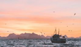
This activity is beginning to overwhelm the local coastal sea life, which in turn could have economic consequences for the fishing and tourism industries that both depend on healthy corals and the fish they attract. The new maps can hopefully provide governmental agencies and NGOs with the information they need to better plan future developments and ensure the continuation of the reefs for the betterment of biodiversity and local business.