In 2019, we lost an area of rainforest the size of a football field every six seconds. This included a total of almost twelve million hectares of trees in the tropics. Almost four million hectares of these were dense rainforests that had grown over centuries. These forests provide a habitat for many animals and plants and act as a crucial global carbon sink. But our forests are not only shrinking due to massive, sometimes illegal deforestation. In recent years, devastating forest fires have also raged due to climate change, such as those we saw in Australia in early 2020.
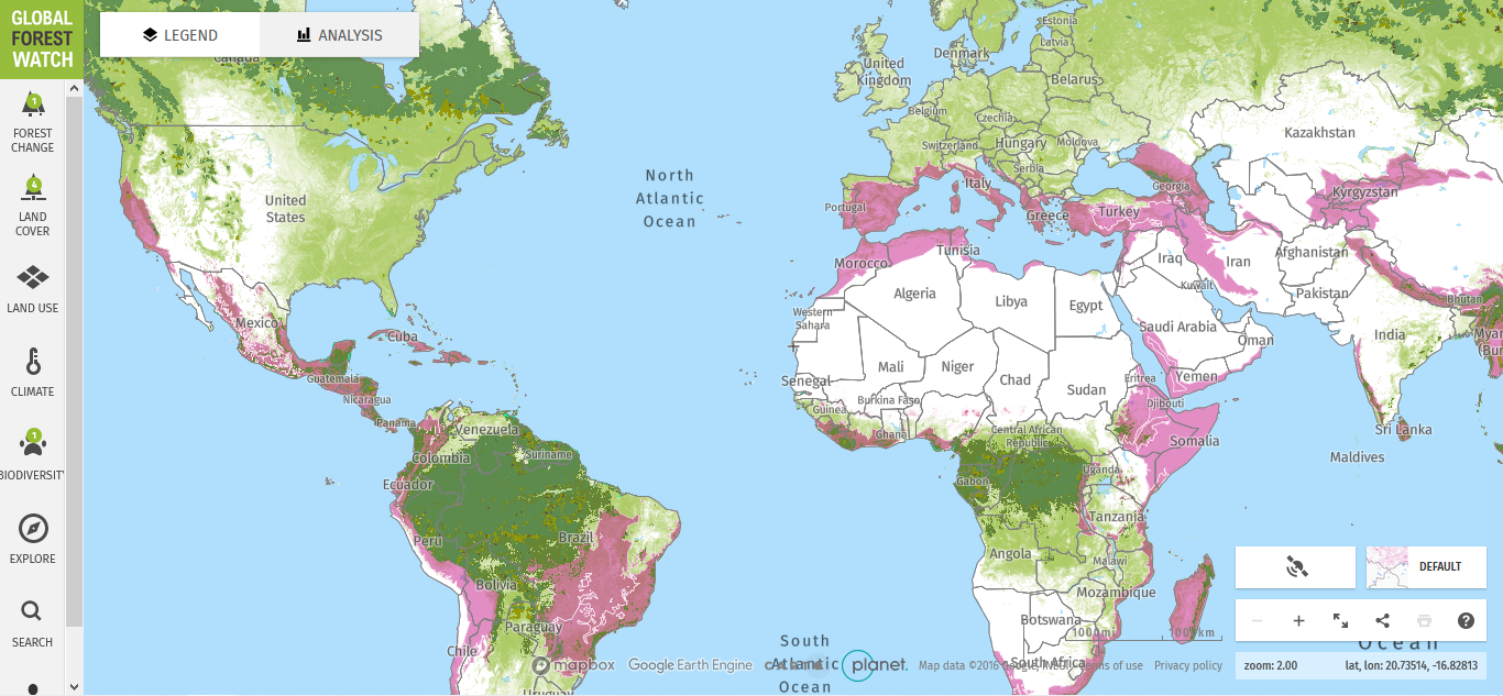
For a long time, it was only ever possible to work out the scale of tree loss after the fact. With the online platform and interactive maps provided by Global Forest Watch (GFW), activists, NGOs, scientists and governments can access a huge treasure trove of – practically real-time – data on forests worldwide free of charge. This data can be used to monitor and manage forests, stop illegal logging and fires, denounce unsustainable activities, defend land and the resources it contains, source raw materials sustainably, and conduct research for conservation.
From a small network to a global community
The platform was founded in 1997 by the World Resources Institute (WRI). GFW initially started as a network for various NGOs reporting on the state of forests in individual countries. Over the years, the community working on or with the platform grew larger and more international. Then, in 2004, GFW also began working with national governments for the first time, jointly developing online maps of local tree cover.
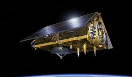
The data is supplied by satellite missions from NASA, ESA, and more recently, high-resolution imagery from Planet, following a deal with Kongsberg Satellite Services (KSAT) and its partners Airbus and Planet by the Norwegian government to provide open access to high-resolution satellite imagery of the tropics. It also incorporates other publicly available information from governments, NGOs, research institutes and companies. The maps are based on various satellite-based geoinformation systems (ArcGIS) from the US software manufacturer ESRI. These map the world’s forest resources in near real time.
In 2006, in cooperation with Greenpeace, GCW created the first worldwide map of intact forests. In addition to information on the condition of forests, other information was added, for example on individual raw material supply chains or major forest fires. In 2017, an app was added that allows users to access GFW data and functions offline. Through cooperation with leading financial and commodity companies, “GWF Pro” was launched in 2019. This project aims to help companies manage deforestation risk in their supply chains.
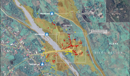
Today, users can view a wide range of information on the platform’s interactive maps: for example, current forest fire or deforestation warnings, land use and forest cover, the locations of palm oil factories, CO2 emissions due to deforestation, and areas where there is a high level of biodiversity.
Protection of mangrove forests and localization of palm oil mills
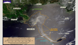
Collected and pooled knowledge provides a good starting point for highlighting political grievances and denouncing them. Through the images of the satellites, numerous committed users of GFW can access information that helps them in their commitment to a more environmentally friendly and less climate-damaging world and a protection of the world’s forest resources. For example, Philippine Congresswoman Susan Yap cited data from GWF showing the loss of mangrove forests to argue in the House of Representatives for the protection and reforestation of this tree species. As a result, a mangrove conservation and rehabilitation bill was approved, which includes a ban on any activity that leads to the damage or destruction of mangrove forests.
With the inclusion of and cooperation of large companies, who are increasingly feeling the pressure to carry out more responsible resource extraction, large and significant steps are being taken towards a greener economy, as the example of the Universal Mill List (UML) shows. It was created by the World Resources Institute (WRI), the Rainforest Alliance (RA), Proforest and Daemeter to track palm oil supply chains, making it easier for companies to monitor resource extraction. The list identifies a total of 1,815 palm oil mills in a total of 26 countries and displays them with relatively precise location on the platform’s maps. With the help of the data collected by the international GFW community, which is now available free of charge, raw material tracing will become much easier. This is because, until now, despite companies increasingly committing to more resource- and environmentally-friendly raw material extraction, tracing individual resources often proved to be very complicated. The UML integrates company data contributed by processors, retailers and consumer goods manufacturers to the Roundtable on Sustainable Palm Oil (RSPO) and FoodReg. Large companies such as Unilever and Mondelēz International also actively participated in the creation of the list.
The website has many more examples where the map data has become a tool for improved conservation measures. According to the website, the platform is used by thousands of people every day. Since 2014, four million people from all countries around the world are said to have already visited the platform. Partners that financially support GFW include Google and the United Nations Environment Programme (UNEP), among many others. Other partners include Airbus, the University of Cambridge and many other academic and non-profit organizations.
This article is part of the RESET Special Feature “Satellites for Sustainable Development”. Click here to explore all of the articles in the series.
This is a translation of an original article that first appeared on RESET’s German-language site.