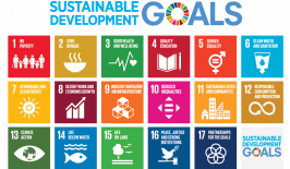
No poverty, no hunger, clean water and sanitation, sustainable cities and communities, climate protection and sustainable consumption and production – these are just a few of the 17 goals agreed upon by the members of the United Nations. In September 2015, the Sustainable Development Goals, or SDGs for short, were laid out in the “2030 Agenda for Sustainable Development” at the UN Sustainability Summit in New York. This latest version of the global SDGs take all three dimensions of sustainability equally into account: social, environmental and economic.
This set of goals was drawn up five years ago, along with a set of 232 indicators that was developed to measure and evaluate the progress, largely based on demographic and statistical data, as well as using data from environmental monitoring networks, models and surveys. One of the methods for environmental observation is satellite remote sensing. In combination with other geo and statistical data, this method is used to record both changes in the environment and society.
As part of the Cop4SDGs project, researchers from the German Federal Office of Cartography and Geodesy are looking at which of the 232 sustainability indicators can be recorded and better verified by satellite remote sensing. To do this, they are using satellite data from the European earth observation programme Copernicus. The Cop4SDGs project is supported by the funding from the German Federal Ministry for the Environment, Nature Conservation and Nuclear Safety and is being carried out on behalf of the German Environment Agency (UBA). It is hoped that the results of the Cop4SDGs project will provide information on whether the methods developed can also be used for other political applications too – for example monitoring the application of the German Climate Action Plan 2050. The project also contributes to “EO4SDG” and the Euro-GEO project. Both of these are investigating the potential of Earth observations to advance the UN 2030 Agenda.
Tracking air pollution and water ecosystems from outer space
Of course, not all of the 232 indicators for sustainable development can be verified using satellite or remote sensing data – social goals such as gender equality (Sustainability Goal 5) will have to be monitored using other methods.
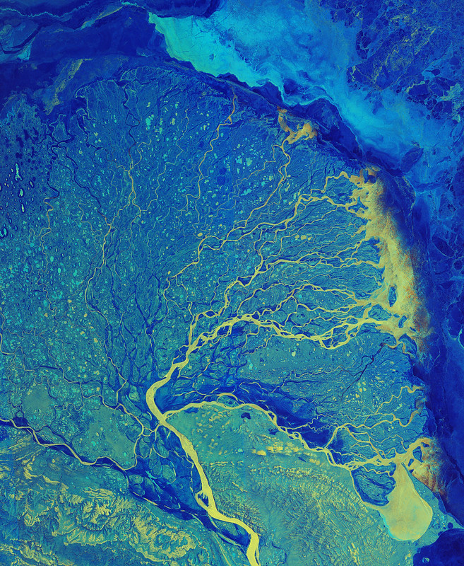
However, the researchers working on the Cop4SDGs project were able to identify 14 promising indicators. Two of them have been studied in more detail so far: mortality from air pollution and the change in the extent of water–related ecosystems over time. The 232 sustainability indicators are each assigned to one of the 17 SDGs and one of the 169 sub-objectives. The change in the extent of water–related ecosystems over time, for example, is part of UN sustainability goal number 6: “Ensure availability and sustainable management of water and sanitation for all” and is therefore also numbered with a 6 at the beginning – resulting in the number 661.
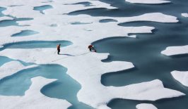
Indicator number 661 looks at the relationship between land and water and how it changes over time. Aerial photography of large areas of land has demonstrated that working with satellites is a good way of verifying this particular sub-target of the SDGS. Satellite data can also help with the sub-indicator mortality from air pollution that’s related to SDG Number 3: “Health and well-being”, as satellites are able to measure air quality throughout large areas.
The methods were defined by the United Nations Environment Programme (UNEP). “When it comes to analysing ecosystems, as in the case of indicator 661, for example, we’re using data on the areal extent of wetlands and artificial and non-artificial lakes,” explains Patrick Knöfel, scientific researcher at the Federal Office of Cartography and Geodesy.
The advantage of Copernicus’ satellite images is that they are very up-to-date, as new images are freely available every three days. Although one downside is that the satellite images are only available in low resolution, as project manager Michael Hovenbitzer explains. Clouds can also restrict the view of the earth from space. For this reason, the researchers always work with a combination of satellite and other (paid) remote sensing data. The latter have a higher resolution, which is particularly important for the classification of land use, despite usually not being as up-to-date as satellite data.
Land cover model provides information about land cover and land use
As well as the Cop4SDGs project, the Federal Office of Cartography and Geodesy is also working on a “land cover model”. This model uses remote sensing data, including data sets from the Copernicus satellites, to collect and classify information on land cover and land use in Germany. This information will be used by the researchers of the Federal Office of Cartography and Geodesy for the Cop4SDGs project. The data is also made available to the German environmental authorities and will be passed on to the European Environment Agency every six years. The model also represents Germany’s contribution to the Europe-wide CORINE Land Cover (CLC) project. CORINE stands for the European project “Coordination of Information on the Environment”.
Especially when it comes to the environment, and climate and ecosystem change, working with satellites offers many opportunities, as they provide a wide range of up-to-date information and can thus make an important contribution to tracking – and ultimately realising – the UN’s 17 Sustainable Development Goals.
This article is part of the RESET Special Feature “Satellites for Sustainable Development”. Click here to explore all of the articles in the series.
This is a translation of an original article that first appeared on RESET’s German-language site.