When it comes to pollutants in the air, carbon dioxide is usually considered the prime offender. Although this might be true, there is, in fact, a rogue’s gallery of other pollutants which also contribute to environmental degradation, but which often avoid the public limelight.
One such pollutant is sulphur dioxide (SO2), a compound which is often released via ore smelting and the burning of oil and coal in power stations. As well as being an irritant and air polluter, sulphur dioxide can also mix with water in the air to become ‘acid rain’ – destroying plant life, infrastructure and the water quality of streams and lakes. One of the main challenges regarding SO2 is understanding its source, plotting its source of travel and differentiating man-made sources of SO2 from natural ones – such as from volcanoes.
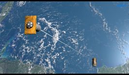
Luckily, a European satellite, Sentinel-5P, now has the ability to track the presence of sulphur dioxide in the atmosphere – exposing polluters, but also providing various institutions with the data set required to better tackle the issue.
Launched in 2017, the Sentinel-5P satellite is a collaboration between three European nations as part of the EU’s Copernicus Earth-monitoring programme. Constructed by Airbus in the UK, the satellite also features special instruments designed in the Netherlands, while Belgian experts help to decipher the information coming through. The jewel in Sentinel-5P’s crown is the Tropomi (TROPOspheric Monitoring Instrument), a spectrometer capable of scanning the Earth’s atmosphere through ultraviolet (UV), visible (VIS), near (NIR) and short-wavelength infrared (SWIR) spectrums.
With the Tropomi, Sentinel-5P can highlight a wide range of pollutants, including ozone, methane, carbon monoxide and sulphur dioxide, with previously unachieved levels of resolution and accuracy.
Spotting Sulphur Dioxide

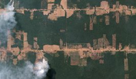
Although still not fully operational, the team behind Sentinel-5P elected to reveal portions of its sulphur dioxide findings to illustrate the capabilities of the satellite. The Tropomi instrument was able to highlight the most significant areas of sulphur dioxide production, most notably the Arabian Gulf’s oil industry and Indian coal power plants.
The Russian mining and smelting industry, although small in comparison to power plant sulphur emissions, also stood out for particular attention. Some power plant emissions are “scrubbed” before entering the atmosphere, removing some of the most harmful pollutants, however this is not common with smelting operations. For example, one smelting town in Siberia, Norilsk, is responsible for 1% of all global sulphur dioxide emissions and features a sulphur dioxide concentration which is often one thousand times higher than the average for Europe. Discussing the findings, Dr Nicolas Theys of the Royal Belgian Institute for Space Aeronomy (BIRA-IASB) told the BBC:
“We can clearly distinguish the different power plants. As we get better with the data and reduce the noise, we will probably be able to estimate the quantity of emissions coming from individual power stations and complexes.”
Meanwhile, the Norilsk data in particular revealed how sulphur dioxide travels in the atmosphere, revealing the different transport pathways the pollutant takes. Armed with this information, NGOs and government institutions can better link pollutant producers directly with evidence of environmental damage elsewhere – creating a strong sense of accountability.
The Sentinel satellite leaders hope that this information can also be better linked into weather reporting on television and via apps, informing the public of air quality conditions as well as the dangers of sulphur dioxide and other pollutants.
As for the future of the satellite, Sentinel-5P is soon to go operational with the Tropomi instrument in the detection of carbon monoxide and nitrogen dioxide in the atmosphere. The team is still tinkering with the final elements of its sulphur dioxide detection, with it expected to go operational this autumn.