Based out of San Francisco, Saildrone is a maritime technology company which aims to provide high-tech automated solutions for marine research and commercial activity. The patented design behind their titular product was originally devised for something quite other than ocean surveying: breaking the land speed record. However, CEO Richard Jenkins then discovered his knowledge in aerodynamics and carbon composite structures could be applied to new frontiers.
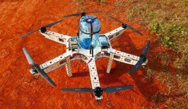
The saildrone is technically a USV – unmanned surface vehicle – comprising a seven-metre long hull and 5-metre tall sail. Weighing in at around 750 kilograms, it is substantially larger and heavier than most commercial drones, including those used on the water. Its size, however, allows it to carry an extensive suite of scientific and monitoring equipment which can measure up to fifteen different metrics, including temperature, ocean salinity, ocean currents, fish biomass and carbon.
The saildrone itself is propelled by wind power and can cover up to 150 kilometres a day in ideal conditions. Generally, a saildrone can carry out missions for up to around 12 months. During this time, they navigate autonomously, while being in constant connection with human supervisors via satellite.
Sail Technology for Modern Research
The technology has the potential to radically alter the traditional means of gathering in situ data regarding our seas and oceans. Previously, researchers had to rely on sensors, often stationary, to record only a small number of metrics. Alternatively, they could use research vessels, which come with all the costs and complications of staffing, supply and maintenance. Saildrone COO Sebastien de Halleux told RESET:
“Research vessels and buoys are expensive to deploy and maintain, and there aren’t enough of them. The National Oceanic and Atmospheric Administration has only 16 research vessels and there are fewer than 200 offshore buoys globally. Saildrones are less expensive to operate than research vessels and, because they are powered by wind and solar energy, they are virtually silent while operating so they do not disturb the environment they are surveying.”
The saildrones, which can operate via pre-defined parameters and waypoints, have also been built to survive some of the harshest ocean conditions, which would otherwise be dangerous or impractical for long-term manned research missions.
As well as environmental measuring, saildrones have also been used to track and monitor the size and health of various fish populations, such as Alaskan pollock. This has mostly been conducted in partnership with the National Oceanic and Atmospheric Administration, which oversees regulations on sustainable fishing. According to Saildrone, this information can be used to assess the impact of fishing on various species, as well as advise in the creation of protected areas.
More recently, Saildrone has also been trialled by the US Coast Guard in the field of marine domain awareness. The tools on the saildrone can be used for defence and security purposes, including communications and vessel tracking.
Although this could ultimately have military applications, the tools could also provide some environmental protections, including detecting illegal fishing, oil spills and intrusions into protected areas by unsuitable watercraft.
Building a Saildrone Armada

Much of Saildrone’s previous scientific missions have been attached to testing and proving the concept of an autonomous research vessel. However, saildrones have already circumnavigated the Antarctic, taken carbon measurements, monitored weather systems in Japan and tracked the movement and behaviour of fur seals.
In particular, saildrones could fill in the gaps of previous attempts to measure ocean carbon and temperature which often lacked the endurance on an unmanned device. Although satellites have recently been experimented with in these fields, they do have limitations. Often they can only focus in-depth on a small area of the ocean’s surface, while they often lack spatial and temporal resolution. Cloud cover and other weather can also interrupt signals and measurements. However, as de Halleux explains:
“The saildrone is not a replacement for these existing tools, but rather a complementary tool that will cost-effectively expand the scope of temporal and spatial ocean observation. Saildrones, along with these existing methods, all play an important role in the Global Ocean Observation System (GOOS). Together they form a new ‘observational stack’: satellites for the big picture from space, underwater gliders for the deep ocean, and Saildrones for surface monitoring looking both up at the atmosphere and down at the seabed.”
In July, a saildrone completed another long distance trial, covering the 15,015 nautical miles from Cape Verde in the Atlantic Ocean to Trieste on the Mediterreanean Coast in 274 days. In the future, the company has ambitious plans. It hopes to develop a fleet of around 1,000 saildrones which will then survey all of the world’s seas and oceans. De Halleux explained this project – The Quantified Planet – further:
“Oceans cover more than 70% of the Earth’s surface, and yet they are largely unexplored and undersampled due to the cost and difficulty of collecting in situ data in a marine environment. The Quantified Planet is a vision for how we can dramatically increase in situ data collection. If the global ocean was to be divided into six-by-six-degree squares, you’d get about 1,000 squares. Saildrone’s goal is to continually deploy one vehicle in each of those squares to give us better insights into the planetary systems affecting humanity.”
Currently, around 100 saildrones have been used across the world, the progress of which can be tracked and explored on Saildrone’s website.