RESET Live Talk @re:publica 2021: “Satellites for Sustainability”

51002548221_f43cd8a612_h
© re:publica Berlin

Satellites are powerful weapons in the fight against deforestation, overfishing and plastic waste. But there are downsides too, to the recent huge increase in the number of satellites orbiting the Earth. In RESET's upcoming event at the re:publica conference 2021, we'll be taking a closer look at projects using satellites for the good of the planet, and discussing a whole range of different solutions for sustainable space travel.

Author Sarah-Indra Jungblut:

Translation Sarah-Indra Jungblut, 05.19.21

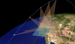
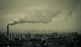
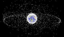
Space travel is developing like never before, with many saying we’re in the midst of a brand new era. When it comes to environmental and climate protection, satellites have already become important tools, uncovering deforestation hotspots and environmental pollution and helping us to better understand the complex interrelationships of climate change and promote effective protective measures. But with the flood of companies and start-ups expanding their business into space with new business models, new problems are also emerging – and not just in orbit. Growing amounts of space debris, high energy and resource consumption during the development and production of satellite technologies, and data protection and privacy concerns are all issues for which we urgently need to find solutions.

In our “Live Talk” (in German only!) on May 21 at 11am as part of the re:publica conference 2021, RESET will talk to Jan Dirk Wegner from EcoVision Lab and John Amos from SkyTruth, who both head up projects using satellite imagery for good. We’ll also visit Holger Krag, who heads the space safety programme at the European Space Agency (ESA) and is working to tackle (quite literally) the problem of space junk – with a giant arm that is to be sent into space to grab bits of debris and remove them from orbit. And Niklas Jordan will present his project OpenSpaceData, with which he wants to make satellite data freely accessible. We’ll follow that up with a live Q&A session with the audience.

The event is free and open for everyone to attend – even if you don’t have a ticket for the re:publica conference itself.

Click the link below to join the discussion:

21st May, 11am: https://zoom.us/j/92939323713

We look forward to seeing you there!

This Live Talk builds on the research and findings of the recently published publication “Greenbook (2): Satellites for Sustainability”, which was funded by the Deutsche Bundesstiftung Umwelt (DBU) and is available for download (in German) here.

Using Satellite Data to Map Air Pollution and Improve Health

NASA scientists will be teaming up with epidemiologists in the agency’s first health-focused mission. With satellite data, they’ll find out how air pollution affects health in cities around the world.

Interview: How Problematic Are Satellites and Drones in Terms of Data Protection?

Are photos made by satellites problematic in terms of data protection? Is there enough regulation around the use of drones? How can we ensure that remote sensing data isn't misused? We talked about all of this with data protection expert Marit Hansen.

Satellite Data Reveals Economic Growth and Pollution Don’t Have to Go Hand in Hand

Do countries really need to sacrifice nature in order to boost their economies? A new report, based on an analysis of satellite data, suggests not - and several countries are already demonstrating the powerful potential to break the links between growth and emissions.

Interview: Space Junk – How Can We Stop Outer Space Turning Into a Garbage Dump?

Satellites offer us crucial information that can help us protect our planet, but while the number of satellites in orbit grows, so does the amount of space junk - dead satellites, pieces of machinery and debris left by humans in space. We talked to Holger Krag from ESA about why space junk is a problem and about what is being done to clean up the mess.

Nico Lang
Interview: EcoVision Lab Is Mapping Biomass for the Good of the Planet

The EcoVision Lab at ETH Zurich is developing a tool that can accurately map biomass - all over the world - using remote sensing data. They hope it will make land-use planning more objective, transparent and environmentally-friendly, as well as protecting forests and biodiversity throughout the globe. We spoke to two of the brains behind the project.

SkyTruth: Using the Power of Satellites to Hold Oil, Fracking and Fishing Companies Accountable

With a focus on oil spills, natural gas fracking and illegal fishing networks, SkyTruth’s work empowers NGOs and members of the public to become environmental watchdogs with a bird’s eye view.