The bus arrives just in time. You have just reached the bus stop and a large double-decker bus is already approaching. That’s just as well, because many more people are heading for the bus along with me. While everyone is getting on, you see a wheelchair user next to me. You ask her if you could help her into the bus. With a glance at her smartphone says that the space for wheelchairs is already occupied here, but there is enough room on the next bus. Other people also stop after all the seats on the bus are taken, because they know — the next vehicle will be along in just two minutes.
This, or something similar, is what public transport could look like. Easily accessible, reliable information to make the journey simple, and a range of connections and vehicles adapted to actual demand to make it comfortable and appealing.
Green Mobility – Digital solutions for a climate-neutral future
Autonomous vehicles, e-mobility, AI-controlled traffic planning, new modes for moving from A to B — what will the mobility of tomorrow look like?
We present the digital solutions being proposed for climate-neutral transport and logistics and discuss the new challenges of “digital mobility” in this dedicated special feature.
The time for development of this simple idea was already yesterday; poor air quality, traffic jams and unchanged high CO2 emissions in traffic have plagued our urban areas for decades. In order to reach this greener future, we need to find ways to not only phase out CO2-intensive internal combustion vehicles as quickly as possible, but also to reduce the number of vehicles overall. So, it makes sense to further expand existing structures that have already proven to be sustainable and to make them more functional and attractive. Systems such as public transport.
Combining the best of both worlds
The idea behind more attractive public transport is to create solutions that combine the comfort of individual transport with the advantages of local public transport. This includes planning based on actual demand. If there is a lot of traffic, vehicles with larger capacities will run; if there is less, fewer smaller vehicles will be sent out. On top of this, passengers must be provided with easily accessible information relevant to their journey. Will my bus arrive on time? Are there enough seats in the next vehicle and will the bicycle still fit? Information on occupancy and current delay times make getting around by bus and train more reliable and easier to plan, and thus pay dividends in terms of public transport comfort.
The prerequisite for this is that the important data for this information is collected and made available. Digital displays on platforms already provide essential information across the world, at least on the arrival of the next train or bus, and occasionally also with accessibility information. And via the mobile apps of the transport companies, such as Jelbi in Berlin, all publicly accessible means of transport are linked and the fastest connections can be easily devised.
According to Jens Schmidt, board member of municipality utility firm Stadtwerke Gießen (SWG),
“Germany is doing quite well in an international comparison. Public transport in Berlin, for example, is often mentioned in the same breath as metropolises such as Tokyo, Shanghai or even London, Amsterdam and Paris when it comes to efficiency and existing infrastructure. However, there is certainly still room for improvement in the area of digitization — in Norway, for example, available public transport data is freely available in real-time and even in standardized, open interfaces. Germany is still a long way from that. Cities such as Seoul in South Korea or Dubai have also invested significantly more in digital, innovative and attractive local public transport in percentage terms.”
Real-time data? Not a chance!
The expected capacity of trains is displayed in the overview of German transport monolith Deutsche Bahn’s trains. Unfortunately, however, this information is not exceptionally reliable as it is forecast-based. The data is based on the number of bookings of saver fares with train connections and the train capacity utilization in the past, so this could easily vary from journey to journey. Real-time data is not yet integrated, which means that the forecasts are often very vague.
Among other things, this has to do with the fact that real-time information is difficult to obtain. “Often, usable data is already available, especially in the proprietary systems of vehicle system manufacturers. However, in many cases, these are not easily made available due to access authorizations or lack of know-how and are usually not stored in a standardized format, which makes fast and efficient use much more difficult,” says Schmidt.
On the one hand, this data could be made more easily accessible to publicly owned transport companies for better forecasting. On the other, there is room for more and better data collection. Although all buses and trams are already equipped with GPS so that their routes and locations can be tracked, passenger numbers are hardly ever collected. Digital passenger counters are one solution, but that would require a huge investment.
But, maybe better solutions are out there. With the help of AI, among other things, highly accurate forecasts of occupancy on public transport can already be made.
NV-ProVI: AI supports the creation of forecasts
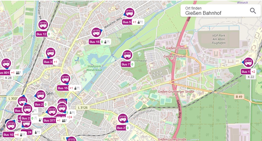
As part of NV-ProVI, a cooperation project between Stadtwerke Gießen and the data analysts at Brodtmann Consulting, an algorithm based on artificial intelligence was developed that uses real-time data to create forecasts for public transport in the next few hours — as well as in real time.
“The real-time information we have realised maps the real traffic situation without any time delay, something that has only been implemented in this form in a few places in Germany so far,” says Schmid, who heads the project. In addition to the actual real-time public transport data — including current position and occupancy — the AI’s forecasts also take into account other relevant factors such as weather data, school and semester holidays or major events.
NV-ProVI is funded by the mFUND research initiative, under which the Federal Ministry of Transport and Digital Infrastructure has been supporting research and development projects relating to data-based digital applications for Mobility 4.0 since 2016. In addition to financial support, the mFUND also offers various event formats for networking between stakeholders from politics, business and research, as well as access to the mCLOUD data portal. Further information: mfund.de
Usefulness for the end user is he ultimate priority. For example, an app that can show how full the bus is at a certain stop at a certain time, or whether it will arrive on time will have real-world applications. Do you run and probably only find a standing room, do you wait for the next bus or find a different route? The app’s data would make this an informed decision and save stress, time and discomfort.
“In the case of NV-ProVi, the goal was to display the real-time data on a live map — in a sense, a proof-of-concept on which concrete use cases can then be realised,” Schmid reports. “This includes, for example, dynamic connection information that not only takes delays into account in real-time but can also suggest less crowded and equally fast alternative routes — as well as offering filters such as the availability of bicycle transport and parking spaces for prams or wheelchairs. It may be even be possible to deploy booster or replacement journeys more quickly and accurately exactly where they are most needed.”
Linked to this is the hope that more people will switch to public transport. After all, the more reliable information is readily available, the better I can plan a route – which definitely contributes to the attractiveness of public transport.
If more people are persuaded to switch to public transport, it can pay off to invest not only in its expansion, but also in digital infrastructures. “However, this conversion still requires financial resources that cannot be generated through fare revenue,” says Schmidt.
The possible applications of intelligent algorithms are pretty much limitless. They could be integrated into comprehensive “Mobility-as-a-Service” apps that link all public transport modes such as car sharing, public transport and rental bikes. And perhaps in the future, fixed timetables and stops could be replaced by a dynamic deployment of buses and trains that is geared to people’s actual needs and movement patterns.
Transaction data — a precious commodity
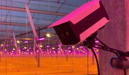
Other data sources could also become decisive: movement data. The cameras, which have already been installed in many vehicles and stations for security reasons, could also be used to measure passenger flows with the help of modern image processing, as is being tested in the Artificial Intelligence Passenger Counting (AIPaC) project, for example. And in the Smartphone Sensing in Public Transport (SSTP) project, researchers are evaluating smartphone data from test persons, which they bundle pseudonymously. The aim is to record which mobility apps passengers use and to what extent certain locations or times of day influence the decision for or against using public transport.
However, making movement data available brings with it enormous challenges. It cannot only be used to map people’s actual journeys, but also has the potential to be used to extract very private information. The legal and ethical implications demand sophisticated mathematical and technical anonymisation procedures. “We believe that greater acceptance by users can only be achieved if data misuse can be reliably ruled out. This requires new methods for anonymising data,” says Qais Kasem, who heads the SSTP project. Within the framework of the project, several methods of adding “noise” to the data are underway. The fact that third parties will not have access to the raw data is guaranteed.
Even if the transport network can be further optimised with detailed forecasts, digital solutions alone are of course not enough for seamless and attractive public transport. Further expansion of the infrastructure is also necessary so that more people switch to buses and trains. Extra lanes and priority for buses and trams, for example, ensure that vehicles do not get stuck in traffic jams. In addition, there is a pricing policy that makes public transport affordable — the residents of the city of Vienna, for example, are mobile all year round with the 365-Euro-Ticket. Some cities even go so far as to offer their public transport free of charge; in Tallinn and even in the whole of Luxembourg, public transport is free. Could this be a universal low-tech solution for a greener future? We think so.

